

By Delmar Cain
I am sure that it goes without saying that age does not necessarily improve everything. The creaks in my knees that show up with the changes in temperature are not an improvement. Apparently age and changing temperatures have not improved the USDA hardiness zone map that was last revised in the 1990’s; and so the United States Department of Agriculture released a new one on January 24, 2012.
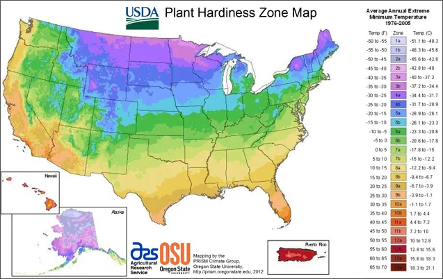
A hardiness zone map is handy information for farmers and gardeners about the probable low temperatures for an area, gathered from annual temperature readings. It is especially useful when combined with information of the cold hardiness of individual plant species.
The USDA divided the North American continent into zones beginning numerically from Northern Alaska. The zones are based on a 10 degree-Fahrenheit difference in the average low temperature from one zone to the next. For more detail each zone was then subdivided into an “a” and a “b”, based on a 5-degree difference.
The 1990 map used 13 years of average low temperatures from the years 1974 to 1986. The new map released in January is based on 30 years of temperatures from 1976 to 2005. On the old map all of Kendall County was in the 8a zone. According to the new map Kendall County is divided with approximately half being in 8a and half being in 8b. Gardeners in the 8a zone should plant anticipating that winter temperatures can reach 10 to 15 degrees. In the 8b zone one can anticipate temperatures from 15 to 20 degrees. For an interactive map showing the new zones go to: http://planthardiness.ars.usda.gov/PHZMWeb/
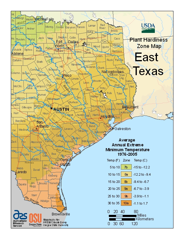
Of course, the information about cold hardiness is only part of the story. Is your location sunny or in shade, is it dry or wet, is the soil bottomland or caliche? And although my house is now in zone 8b, I still don’t know whether I should plant that South Texas native, the anacua tree (Ehretia anacua), which remains in a pot at home.
On the other hand, if you have a dry, hot spot in your yard that gets full sun, consider planting damianita (Chrysactinia mexicana), the February plant of the month for the NICE program of the Boerne NPSOT. According to those members having it in their yard, it is one tough plant.
Damianita is a low-growing (1-2 feet tall and wide) evergreen shrub with a woody base. It is native on caliche and limestone outcrops in the lower Edwards Plateau, west into New Mexico and south into Mexico. It forms a rounded mound and will spread by seeds, growing on what might appear to be eternally fallow soil. On a trip to the 3 K’s Ranch with Rufus Stephens, Wildlife Biologist for TPWD, I was amazed to see damianita growing on the south facing-edge of an old ranch road in very hard caliche at one of the higher elevations. How could the seeds get there and how did they sprout under those conditions?
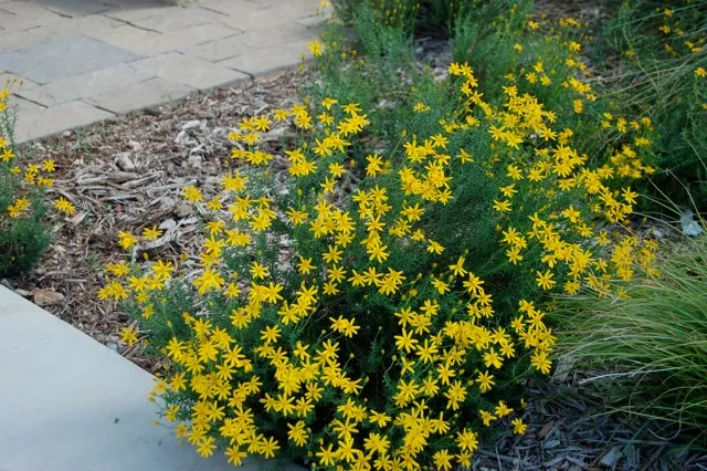
The leaves of the plant are dark green and remind me of rosemary in the way that they cover the stems. The foliage is aromatic and is not a favorite of either deer or rabbits. The solitary yellow flowers extend from the branch tips on 1-3 inch peduncles. Each composite flower is one-half to one inch wide with eight or so ray flowers around the head.
Damianita is very drought tolerant when established, although I must confess to having killed a couple in the process. I think I might have overestimated its ability to establish this past summer. If the ground is parched give it a chance with periodic watering. The Boerne NPSOT website has planting instructions. One thing should not be a cause of concern. It is freeze hardy to 0 degrees. Under the new USDA hardiness map, damianita is safe to grow all the way to Amarillo in zone 7a, if you have the right kind of soil.
By the way, Becky Eterno, who chairs the Boerne chapter NICE committee, reports that Hill Country Gardens in New Braunfels has a good selection of damianitas. If you are over that way drop in and check them out.