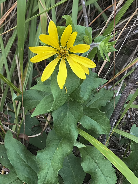

Starry Rosinweed

Silphium asteriscus

Other common name(s):

Roughleaf Rosinweed, Whorled Rosinweed, Simpson's Rosinweed

Family:

Asteraceae (Aster Family)

Plant Ecoregion Distribution Map

This map uses data from the US EPA. EPA  servers have been offline frequently so maps may not display. We are working on a solution.

Cross Timbers, Edwards Plateau, Western Gulf Coastal Plain
Eastern Cross Timbers, Grand Prairie, Limestone Cut Plain
Balcones Canyonlands, Edwards Plateau Woodland, Llano Uplift
Flatwoods, Floodplains and Low Terraces3, Pleistocene Fluvial Terraces, Red River Bottomlands, Southern Tertiary Uplands, Tertiary Uplands

Plant Characteristics

Growth Form

Herbaceous

Height

2
to
5
ft.

Spread

0.4
to
1
ft.

Leaf Retention

Deciduous

Lifespan

Perennial

Habitat and Care Requirements

Soil Type(s)

Dry, Sand, Well Drained

Light Requirement

Sun, Part Shade

Water Requirement

Medium

Native Habitat

Grassland, Woodland

Bloom and Attraction

Bloom Color

Yellow

Bloom Season

Summer, Fall

Seasonal Interest

Nectar, Pollen, Seeds

Wildlife Benefit

Bees, Birds, Butterflies

Maintenance

Common uses include bee garden, bird garden, butterfly garden, deer resistant, drought tolerant, and low maintenance. Native habitat: open woods, glades, flatwoods, prairies, sandy pinelands, and clearings.

Description

Blooms June-September. Stems hairy towards the tips. Flowerheads are large — up to 2½ inches in diameter. The common name “rosinweed” refers to the gummy or resinous substance found in the stems. Fruit is a cypsela: dry, single-seeded with wispy filaments attached.
Previous Scientific Name(s): Silphium asteriscus ssp. dentatum, Silphium asteriscus ssp. latifolium, Silphium asteriscus ssp. trifoliatum, Silphium asteriscus var. angustatum, Silphium asteriscus var. asteriscus, Silphium asteriscus var. dentata, Silphium asteriscus var. dentatum, Silphium asteriscus var. latifolium, Silphium asteriscus var. latrifolium, Silphium asteriscus var. scabrum, Silphium asteriscus var. simpsonii, Silphium asteriscus var. trifoliatum

About the Region

2026 Fall Symposium Logo

This low-elevations region of Texas extends inland from the barrier islands, about 60 or so miles, and stretches from Brownsville to Louisiana. In total, it covers about 9.5 million acres, with a high point of 150 feet in elevation. More than 1000 species of plants can be found in this region. On the southern end, species more common in Mexico (such as Sabal mexicana) and Central America occur.

The barrier islands provide us with dune systems, and clay flats to the inland side, which have species found in these areas alone. Many plants here, such as Ipomoea pes-caprae (beach morning glory), can be found throughout tropical regions of the globe. I’ve encountered the same species on the beaches of Guam.

Once inland, vast marshes and wet prairies occur. Occasionally, oak (Quercus fusiformis) groves can be found. Common grasses include species of Bothriochloa, Paspalum, and Sporobolus; eastern gamagrass (Tripsacum dactyloides); and switchgrass (Panicum species). Many rivers and creeks cut through the Gulf Prairies, and along these riparian areas various species of trees, Sabal minor, and other plants adapted to clay soils can be found. Due to overgrazing, farming, and fire suppression, woody species such as mesquite (Prosopis glandulosa) and huisache (Acacia farnesiana), and invasive species such as chinaberry (Melia azedarach), Brazilian pepper (Schinus terebinthifolius), and Chinese tallow (Sapium sebiferum) have increased and displaced our native flora.

Source: Wildflowers of Texas by Michael Eason