


Attendance for most field trips is limited, and consequently the field trip selection made during event registration is final and cannot be changed at the Symposium. Please review possible choices below and ensure you are comfortable with the option you are choosing (there is also an option for no field trip). Printed field trip information will be available at the symposium. Distance and travel times are estimated from New Braunfels Civic/Convention.
For assistance or questions, email admin-assist@npsot.org. (Please note response will be fastest during office hours of Tuesday 9-1, Wednesday 3-5, and Thursday 9-1.)
Field trips are being finalized and subject to change; additional field trips may be added.
Friday Field Trips
F1 Bracken Cave Preserve
Address: 7515 Bracken Cave Road, San Antonio, 78266
21.5 Miles/35 Minutes
Description:
The Bracken Cave Preserve is home to more than 15 million Mexican free-tailed bats (Tadarida brasiliensis), one of the largest concentrations of a single species of mammals on earth. The surrounding preserve is home to Hill Country karst topography and contains a large number of old-growth Oak and Ash Juniper (or ‘Cedar’) trees. Field trip leaders will include Bracken Cave Preserve volunteers and the discussion will focus on native plants and ongoing regeneration of the habitat. Please note this trip does not include a visit to the interior of the cave or bat viewing.
Links
https://www.batcon.org/see-bats-live/visit-bracken-cave-preserve/
https://tpwd.texas.gov/huntwild/wild/species/bats/bat-watching-sites/bracken-cave-preserve.phtml
Field Trip Leader: Bracken Cave Preserve Volunteers
Difficulty: Moderate; rough and uneven terrain along the walk.
Wheelchair/ADA Accessible: No
Start Time: 1:45
Estimated Duration: 2 Hours
Maximum Number of Attendees: 30 (in multiple groups)
Fees: None
Facilities: Yes
Other: Carpooling is highly recommended because entry is controlled via gate. Once the gate is closed, entry will not be possible.
Written Directions: TBD
Google Map Link: https://maps.app.goo.gl/5ZdKyyz9UdS8Fo8S6
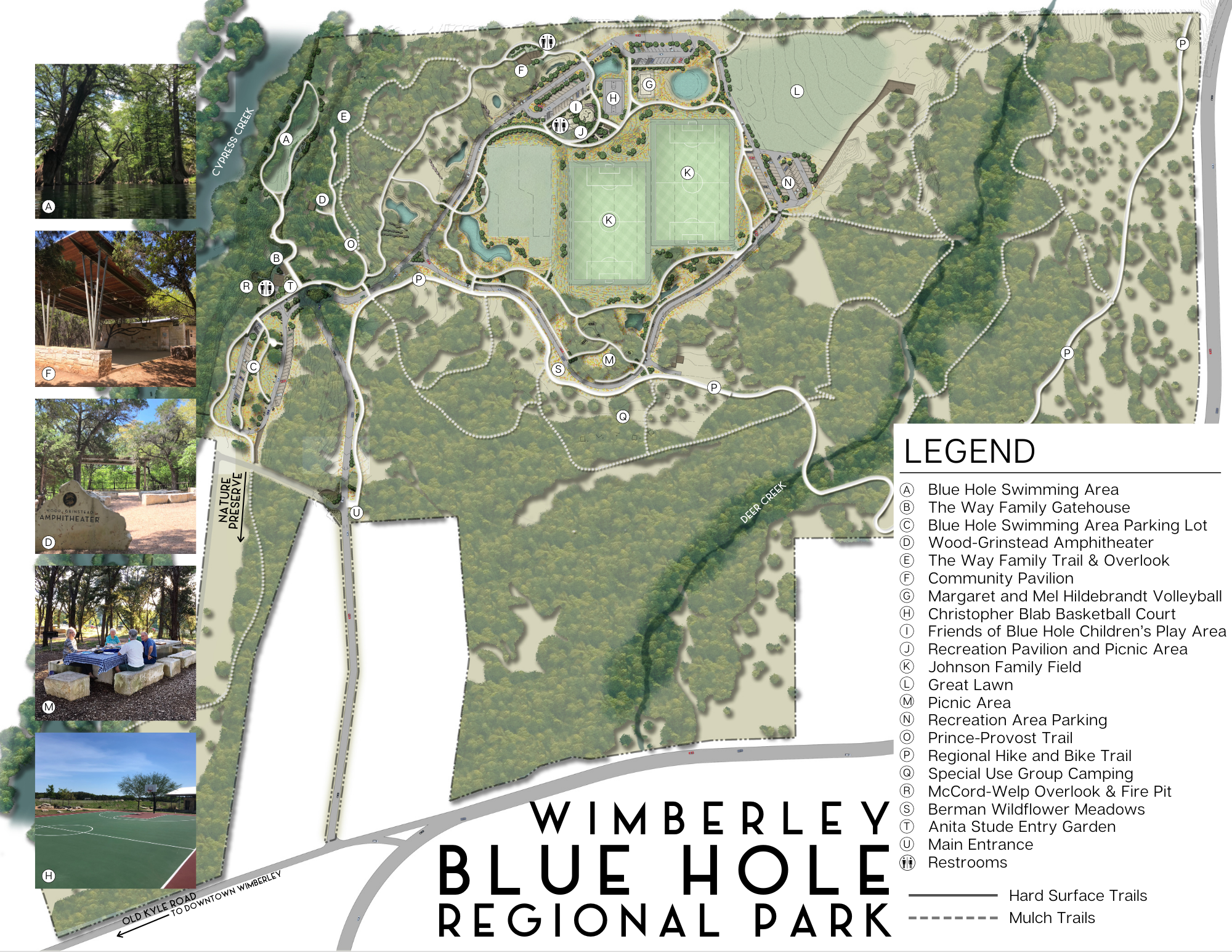
F2 Blue Hole Regional Park / Cypress Creek Nature Trail & Preserve
Address: 333 Blue Hole Lane, Wimberley 78676
32 Miles/41 Minutes
Description:
Blue Hole Regional Park is in the heart of the Texas Hill Country. This Wimberley park’s key feature is the iconic Blue Hole, a stunning natural swimming area fed by the crystal-clear waters of Cypress Creek. The water’s distinct blue hue, combined with the lush surroundings, creates a serene and inviting atmosphere for the walk. Cypress Creek Nature Trail & Preserve is 7.24 acre preserve and city park adjacent to Blue Hole and it features hiking and biking trails. The tour will be a linear walk moving along Cypress Creek.
Links:
https://wimberleyparksandrec.com/blue-hole-regional-park/
https://fh-sites.imgix.net/sites/7034/2023/12/04153116/Document41.png
Field Trip Leader: Wimberly Park Staff or Park Volunteer
Difficulty: Easy but with some uneven ground
Wheelchair/ADA Accessible: No
Start Time: 2 PM
Estimated Duration: 2 hours
Maximum Number of Attendees: 20
Fees: No
Facilities: Yes
Other: Transportation may involve carpooling; will meet at picnic tables in the swim area parking lot
Written Directions: TBD
Google Map Link: https://maps.app.goo.gl/r8UcaSziJYmvuP2TA
F3 Crescent Bend Nature Park
Address: 12805 W. Schaefer Road, Schertz, TX 78108
Miles/Minutes: 17 Mi/26 Min
Description:
The homes in this flood-prone subdivision along Cibolo Creek were purchased and demolished and a park was established in its place. The area is being regenerated with native plants such as inland sea oats and Turk’s cap which support a wide variety of insects, reptiles, birds, and mammals. The City of Schertz partners with the San Antonio Zoo and allows the collection of harvester ants from the park to supplement the diet of the Texas Horned Lizards raised at the zoo as part of their Conservation Program. The zoo provides educational programs to the public at the park three times a year. The site is a mixture of prairie, woodland and riparian plants making this a birding hot spot with over 250 species reported by Audubon groups and individuals. The crushed granite walking trail is 1.3 miles with point-of-interest markers.
Links:
https://friendscbnp.zenfolio.com/
Map: https://friendscbnp.zenfolio.com/p759107529/h769fc73c#h769fc73c
Field Trip Leader: TBD
Difficulty: Easy
Wheelchair/ADA Accessible: Yes
Start Time: 1:45 PM
Estimated Duration: 1 Hour
Maximum Number of Attendees: 20
Fees: No
Facilities: Yes
Other: Carpooling recommended
Written Directions: TBD
Google Map Link: https://maps.app.goo.gl/cAGTLKnidfbHRfTD6
F4 Dominick Arboretum
Address: 311 Clear Lake Drive, New Braunfels, TX 78132
Miles/Minutes: 16 Mi/28 Min
Description:
Established in 2008, the Dominick Arboretum is an internationally accredited arboretum representing a diverse native Central Texas hill country wildlife habitat. A goal is to share a mature arboretum that will inspire arborists and future generations of conservation-minded land stewards. The eleven-acre woodland / prairie / riparian ecosystem contains approximately 600 woody specimens, meadows of native little bluestem grasses and wildflowers. 650 trees & shrubs representing 250 native and 50 nonnative adaptive species to our Comal & surrounding counties within the Edwards Plateau ecoregion have been planted. You will likely see native birds, butterflies, bees, and deer and be provided food for feeding the fish in the various ponds.
Links: http://arbnet.org/morton-register/dominick-arboretum
Field Trip Leader: Leon Dominick
Difficulty: Moderate Terrain
Wheelchair/ADA Accessible: No
Start Time: 1:45 PM
Estimated Duration: 1.5 Hours
Maximum Number of Attendees: 20
Fees: No
Facilities: Yes
Other: Wear sturdy shoes, hats, and sunscreen protection. Bring your cameras, woody plant books & questions. We will provide cold water, otherwise bring your preferred beverage. Carpooling recommended.
Written Directions: TBD
Google Map Link: https://maps.app.goo.gl/ih5oSeD9Ggtx7jNz7
F5 Hardberger Park / Robert L.B. Tobin Land Bridge
Address: 8400 NW Military Hwy, San Antonio, TX 78231
Miles/Minutes: 47 Min/32 Mi
Description:
Phil Hardberger Park, opened in 2010, is a 311-acre sustainable natural urban park that is 75% wildlife preserve and 25% set aside for recreation. The park contains two playscapes on either side of the park, a nature play area for children, dog parks on both sides of the park, picnic facilities, basketball courts, an outdoor classroom, a children’s vegetable garden, a wildscape demonstration garden, a restored wetland, the Salado Creek overlook, the Skywalk, and the Robert L.B Tobin Land Bridge. The park, a former dairy farm, is bisected by Wurzbach Parkway running between N.W. Military Highway and Blanco Road. The park has been reconnected with the first dual-use land bridge for wildlife and pedestrians connecting the west side’s 3.64 miles of trails and the east side’s 2.84 miles of trails. The park is located at the conjunction of 3 different ecoregions, the Edwards Plateau, Blackland Prairies, and South Texas Plains that lead to remarkable diversity of vegetation in the park. The land bridge also connects to the Salado Creek Greenway trail system which is over 16 miles of trail.
Links:
https://www.philhardbergerpark.org/
https://www.philhardbergerpark.org/map
https://www.philhardbergerpark.org/land-bridge
https://www.philhardbergerpark.org/s/Park-Map-flyer-2022-flat-terrain.pdf
Field Trip Leader: Wendy Leonard, Assistant Manager,
City of San Antonio Parks and Recreation Natural Areas
Difficulty: Easy to moderate; the trail to the land bridge is a mixture of decomposed granite and stalok which is different from the natural surface trails which are a bit more difficult. It is mostly flat terrain with a gradual incline when on the land bridge.
Wheelchair/ADA Accessible: No; however, the trip is possible with participants being assisted in wheelchairs
Start Time: 2 PM
Estimated Duration: 4 Hours
Maximum Number of Attendees: 80, in multiple groups
Fees: No
Facilities: Yes
Other: Traffic in San Antonio may impact travel times. Carpooling recommended.
Written Directions: TBD
Google Map Link: https://maps.app.goo.gl/M5ACQFQRRVoNVr5u5
F6 Honey Creek State Natural Area
Address: Guadalupe River State Park, 3350 Park Road 31, Spring Branch, TX 78070
(Meeting at Rust House inside the park)
Miles/Minutes: 32 Mi/42 Min
Description:
A most Recent Success of The Nature Conservancy and Texas Parks and Wildlife, this canyon and floodplain conservation area includes restricted access to 2 miles of trails and rich fauna. Imagine the Hill Country of 100 years ago – or see it for yourself at Honey Creek State Natural Area. This protected piece of land harbors plants and animals nurtured by a 1.5-mile spring-fed creek. Access to Honey Creek is only by guided tour and it has grown by 515 acres due to a recent land purchase. On the tour, you’ll hear about the history, geology, plants and animals of this special place. At the scenic overlook, Spanish moss dangles from live oaks and Ashe junipers. You’ll get a first glimpse of Honey Creek winding through bald cypress trees far below. The tour culminates in a walk by the pristine and peaceful creek.
Links:
https://tpwd.texas.gov/state-parks/honey-creek
State Park Map that includes the Rust House meet-up location: https://tpwd.texas.gov/publications/pwdpubs/media/park_maps/pwd_mp_p4505_040e.pdf
Interpretive Guide: https://tpwd.texas.gov/publications/pwdpubs/media/pwd_br_p4505_0040g.pdf
Bird Checklist: https://tpwd.texas.gov/publications/pwdpubs/media/pwd_bk_p4505_0040b.pdf
Press Release: https://tpwd.texas.gov/newsmedia/releases/?req=20230622a
Additional Information: https://www.backroadstexas.net/honey-creek-state-natural-area-hill-country-history/
Field Trip Leaders: TBD – Honey Creek Hikes Volunteers
Difficulty: Moderate; much is flat, but there are some rocky areas, slopes, and two steep but short hills; The two more challenging areas are toward the latter part of the guided walk. For those who may not think they are able to make it, the option of walking on the access road is an option. It will still be rocky, but the climb is very gradual compared to that of the two steep hills.
Wheelchair/ADA Accessible: No
Start Time: 2:00 PM
Estimated Duration: 2.5 Hrs
Maximum Number of Attendees: 18
Fees: State Park fees apply: be prepared to show a Texas State Park Membership or pay a $7 fee at park entry.
Facilities: There will be one single bathroom inside of the Rust House and none during the duration of the guided walk. Recommendation is to stop down in the day-use area to utilize those facilities before heading over to the Rust House as they are nice and can accommodate a larger group of folks simultaneously.
Other: Carpooling required; Sturdy footwear, water, and sun protection are needed
Written Directions: The park is located at the north end of Park Road 31, adjacent to Guadalupe River State Park, and may be reached by traveling west on State Highway 46, eight miles west of the intersection on State Highway 46 and US Highway 281; or by traveling eastward on State Highway 46, 13 miles east of Boerne. Inside the park, drive up the main park road for about a mile and then turn right towards the Rust House. Please note this Natural Area is only accessible through guided tours
Google Map Link: https://maps.app.goo.gl/sXYM9t81AoE4CAiXA
F7 Jacob’s Well Nature Area
Address: 1699 Mt. Sharp Rd, Wimberley, TX, 78676
Miles/Minutes: 45 Min/30 Mi
Description:
This 81-acre nature area features the Jacob’s Well 12′ diameter perennial karstic spring with a deep-water cave. The well is headwaters of Cypress Creek which flows through Blue Hole Regional Park and feeds into the Blanco River. Hays County purchased the first 50 acres of land around Jacob’s Well in 2010 in an attempt to protect the spring from development. Thirty-one acres was transferred to the county from the neighboring Jacob’s Well Natural Area which was created to protect the Wimberley Watershed. The site has plant displays, water harvesting and rain garden, and a walking trail to the spring. David Baker is responsible for preservation of the land, creator of the “One Water” School in Wimberley and has offered to lead the group if wanted. He is the Exec. Director of the Watershed Association. There is also a labyrinth, and the Hays County Master Gardeners maintain several demonstration gardens on site.
Links: https://www.hayscountytx.com/jacobs-well-natural-area
Field Trip Leaders: Hays County Park Staff
Difficulty: Some stairs; various compacted granite and natural surface trails. While we do not consider our tours to be strenuous, you will travel up and down several inclines and walk on rock ledges. Approach to and from the well is quite steep and without handrails.
Wheelchair/ADA Accessible: No
Start Time: 2:00 PM
Estimated Duration: 1.5 Hours
Maximum Number of Attendees: 20
Fees: No
Facilities: Yes
Other: Carpooling recommended
Written Directions: TBD
Google Map Link: https://maps.app.goo.gl/ruDppiAEyhEFQHqJA
F8 Meadows Center for Water & the Environment Walking and Boat Tour
Address: 201 San Marcos Springs Dr., San Marcos, TX 78666
Miles/Minutes: 21 Mi/21 Min
Description:
The Meadows Center for Water and the Environment is an educational center focused on Spring Lake and the more than 200 springs that form part of the San Marcos River. The river is a ‘critical habitat’ home to several aquatic animals, and Texas Wild Rice. A presentation, wetland boardwalk walking tour and glass bottom boat tour will be included.
Links: https://www.meadowscenter.txst.edu/
Field Trip Leaders: Meadows Center Staff
Difficulty: Easy
Wheelchair/ADA Accessible: No
Start Time: 1:45 check in
Estimated Duration: 2 Hr
Maximum Number of Attendees: 100 (in multiple groups)
Fees: $9.00
Facilities: Yes
Other: Carpooling recommended; Vehicles parked at the Meadows Center during the field trip (between 1-5 PM) must display a valid Texas State University parking permit or purchase a one-day temporary permit available for $3 at the pay-and-display station located near the ticket kiosk.
Written Directions: TBD
Google Map Link: https://maps.app.goo.gl/8iZAmtJY2qWjy7K27
F9 Purgatory Creek Natural Area – Lower Purgatory
Address: 2101 Hunter Road Meet (up point)
Miles/Minutes: 4.5 Mi/12 Min
Description:
Purgatory Creek Natural Area is a 700+ acre preserve is the result of successful efforts to preserve this riparian greenbelt. The tour will include a trail walk through the area. The site is a success story for the San Marcos Greenbelt Alliance. This tour will cover Lower Purgatory, the most popular trailhead.
Links:
Description: https://smgreenbelt.org/natural-areas/#purgatory-creek
Map: https://smgreenbelt.org/wp-content/uploads/2020/09/Purgatory-8.5×11-update-9.9.2020.pdf
https://www.visitsanmarcos.com/things-to-do/outdoors-and-nature/purgatory-creek-natural-area/
Field Trip Leaders: Lance Jones
Difficulty: Moderate difficulty with some elevation changes and uneven terrain
Wheelchair/ADA Accessible: No
Start Time: 1:30 PM
Estimated Duration: 1.5-2 Hrs
Maximum Number of Attendees: 25
Fees: No
Facilities: Yes
Other: Carpooling recommended as there are only 35 total parking spaces; There is a water fountain and a single restroom. Closed-toe shoes, long pants, and bringing a water bottle are suggested.
Written Directions: TBD
Google Map Link: https://maps.app.goo.gl/LrnZsjRM7gcERP7X9
F10 San Marcos Discovery Center Nursery Program & Arboretum Trail
Address: 430 Riverside Drive, San Marcos, TX, 78666
Miles/Minutes: 20 Mi/23 Min
Description:
This two-part San Marcos Discovery Center field trip includes 1) a tour of the San Marcos city-run native plant nursery and greenhouse operation supplying the city and community with native plants and 2) a walking tour of the Level 1 Discovery Arboretum Trail. The Discovery Arboretum Trail will take visitors on a tour through a variety of native and adapted woody shrubs and trees. Some of the trees are mature, while some are young and just beginning to establish and grow. The trail is located close to the Balcones fault-line and showcases many species of woody trees and shrubs that can grow on either the Blackland prairie or the Edwards plateau, covering a range of habitats, including riparian, mesic, and upland species. Tree-markers along the trail provide QR code access to species details.
Links:
San Marcos Discovery Center Information: https://sanmarcostx.gov/873/Discovery-Center
Arboretum Trail Map and Plant List: https://sanmarcostx.gov/DocumentCenter/View/11216/The-Discovery-Arboretum-Trail-Map
Field Trip Leaders: Nursery/Discovery Center Staff and Hill Country NPSOT Chapter Volunteers
Difficulty: Easy
Wheelchair/ADA Accessible: Yes
Start Time: 1:30 PM
Estimated Duration: 1.5 Hrs
Maximum Number of Attendees: 20 (In 2 groups)
Fees: No
Facilities: Yes
Other: Limited Parking; Carpooling may be required
Written Directions: TBD
Google Map Link: https://maps.app.goo.gl/QUEJEYxUH5CfJyGU7
F11 Warbler Woods Bird Sanctuary
Address: 19349 Old Wiederstein Rd, Cibolo, TX 78108
Miles/Minutes: 11.5 Mi/20 Min
Description:
Warbler Woods Bird Sanctuary is a 124-acre private preserve, with 40 acres of open grassland, and 80+ acres of woodlands (savannah, heavy understory, and brush). About 295 bird species, including 41 species of warblers, have been listed and it is home to rare species like the Texas Almond.
Links:
http://www.warblerwoods.org
Trail Map: http://www.warblerwoods.org/uploads/3/1/9/9/31992523/visio-wwbs_map_as_drawing.pdf
Field Trip Leaders: Warbler Woods Bird Sanctuary
Difficulty: Easy, unimproved trails with gently rolling topography
Wheelchair/ADA Accessible: No
Start Time: 1:30 PM
Estimated Duration: 1.5 – 2 Hr
Maximum Number of Attendees: 40 (in multiple groups)
Fees: No
Facilities: Yes
Other: Limited Parking; Carpooling suggested; Snakes may be encountered if you go off trail
Written Directions: TBD
Google Map Link: https://maps.app.goo.gl/puArZQJYSyXDZ1YB9
F12 Weston Ranch
Address: 6445 Green Valley Rd, Cibolo, TX 78108
Miles/Minutes: 11 Mi/17 Min
Description:
The Weston Ranch Foundation is the vision of Caroline and Grainger Weston who created this 4,200 acre preserve in a series of acquisitions over 50 years. The Foundation preserves a mixed habitat with examples of both Blackland Prairie and Edwards Plateau plants. Texas Lutheran University has led a multi-year research project of the site’s plant community. Representatives of the Foundation will explain the on-going restoration planning process so far. The Weston Ranch Foundation is working with the NRCS to prepare long-term phasing restoration plan. They have received LIP and EQIP grants to restore Blackland Prairie.
Links: https://www.westonranchfoundation.org/
Field Trip Leaders: Matt Wagner
Difficulty: Moderate; varied terrain, unimproved trails; Rough terrain footwear required.
Wheelchair/ADA Accessible: No
Start Time: 1:30 PM
Estimated Duration: 1.5-1.75 Hr
Maximum Number of Attendees: 40 (in multiple groups)
Fees: No
Facilities: No
Other: Carpooling recommended
Written Directions: TBD
Google Map Link: https://www.google.com/maps/dir/New+Braunfels+Civic%2FConvention+Center,+375+S+Castell+Ave,+New+Braunfels,+TX+78130/29.6175479,-98.1996723/@29.6589219,-98.2025719,15144m/data=!3m2!1e3!4b1!4m9!4m8!1m5!1m1!1s0x865cbd686a7a3355:0xbb436e3f7515f168!2m2!1d-98.121757!2d29.700028!1m0!3e0?entry=ttu
F13 Landa Park Tour
Address: 350 Aquatic Circle New Braunfels TX 78130
Miles/Minutes: 1.2 Mi/4 Min
Description:
Tour historic, lively Landa Park via the park mini-train, with short walking intervals. Train will make stops at key sites in the park, where attendees will tour the William and Dolores Schumann Arboretum, Founders Oak, New Braunfels NPSOT-maintained gardens, and special historic sites, such as a vintage gazebo from 1900 on the edge of Landa Lake. The Dolores and Bill Schumann Arboretum is home to over 80 species of trees making it one of the most diverse arboretums in Texas. This arboretum acts as a “living library” of trees, providing a classroom setting for the study of botany, arboriculture, and other popular interests.
Links:
General Landa Park Information: https://newbraunfels.gov/3375/Landa-Park
Map: https://newbraunfels.gov/DocumentCenter/View/2335/Arboretum-Trail-Map
Arboretum Guide/Plant List: https://newbraunfels.gov/DocumentCenter/View/18110/Rev-Arboretum-Guide
Field Trip Leaders: Gail Groves, Aleta Meyer, and urban forester Jack Hill
Difficulty: Easy
Wheelchair/ADA Accessible: Yes
Start Time: 1:30 PM
Estimated Duration: 1.5-1.75 Hr
Maximum Number of Attendees: 40
Fees: No
Facilities: Yes
Other: Carpooling recommended: Group will meet at the mini train station, next to Landa Haus
Written Directions: TBD
Google Map Link: https://www.google.com/maps/dir/New+Braunfels+Civic%2FConvention+Center,+South+Castell+Avenue,+New+Braunfels,+TX/Landa+Haus,+Aquatic+Circle,+New+Braunfels,+TX/@29.7044621,-98.1378052,15z/data=!3m1!4b1!4m14!4m13!1m5!1m1!1s0x865cbd686a7a3355:0xbb436e3f7515f168!2m2!1d-98.121757!2d29.700028!1m5!1m1!1s0x865c97e29ef9486d:0x922d8ec0693f6f4!2m2!1d-98.1340446!2d29.7108405!3e0?entry=ttu
F14 Canyon Lake Gorge / Dinosaur Tracks
Address: 16029 S Access Rd, Canyon Lake 78133
Miles/Minutes: 18 mi/31 min
Description:
This trip is an adventure more than 110-million years into the past. The Canyon Lake Gorge was carved by the flood of 2002 when more than 67,000 cubic feet of water per second flowed over the spillway of Canyon Lake, marking the first time the spillway was used since the reservoir was completed in 1964. The power of water sliced open the ground below the spillway, exposing more than 110-million-year-old cretaceous limestone, fossils and even dinosaur footprints, unearthing a geological wonder. During guided public tours, visitors will hike 1.25 miles along exposed early cretaceous limestone formations, follow aquifer waters coursing through the Gorge as springs, channels and waterfalls, and see dinosaur footprints. Tour Highlights include geological exposures, exposed faults, fossil treasures, dinosaur footprints, aquifer in action, beautiful lagoons, surprising waterfalls, and dramatic vistas. The tour will be a slow-paced walk through the Gorge with several stopping points for photos and educational information.
Links:
https://canyongorgetours.com/private_tour
https://canyongorgetours.com/
Field Trip Leaders: Canyon Lake Gorge Volunteers
Difficulty: Moderate/Slow-paced
Wheelchair/ADA Accessible: No
Start Time: 1:45 PM
Estimated Duration: 3 Hrs
Maximum Number of Attendees: 20
Fees: $20
Facilities: Yes
Other: Carpooling recommended
Written Directions: TBD
Google Map Link: https://maps.app.goo.gl/ZEhR25RDkH7ymXCGA
F15 Panther Canyon Trail
Address: 15 Gazebo Cir, New Braunfels, TX 78130
Miles/Minutes: 1.5 Mi/6 Min
Description:
Panther Canyon is a 49 acre area adjacent to Landa Park with a recent volunteer-built rim trail addition which added an 0.8 mile segment creating the 1.8 trail loop. Panther Canyon Trail begins near the headwaters of the Comal Springs, which are fed by waters of the Edwards Aquifer emerging within the Balcones fault zone. The trail ascends the Balcones Escarpment into the Edwards Plateau under the shade of oaks, Ashes juniper, cedar elm, and understory trees including Mexican Buckeye, kidneywood, and Texas persimmon. The trail crosses a dry creek bed of ephemeral stream that only flows during or immediately after a rain. The trail covers over 49 acres and is home to many native plants and wildlife.
Links:
https://newbraunfels.gov/Facilities/Facility/Details/Panther-Canyon-Nature-Trail-83
Map: https://newbraunfels.gov/DocumentCenter/View/11298
https://newbraunfels.gov/3375/Landa-Park
Field Trip Leaders: John Davis
Difficulty: Moderately strenuous due to elevation changes; uneven surfaces
Wheelchair/ADA Accessible: No
Start Time: 1:30 PM
Estimated Duration: 1.5 Hours
Maximum Number of Attendees: 40 (in multiple groups)
Fees: No
Facilities: Not on trail (restrooms are available in adjacent Landa Park)
Other: Carpooling recommended
Written Directions: TBD
Google Map Link: https://maps.app.goo.gl/WSCk5HTcmTMjQYUX7
F16 Headwaters at the Comal
Address: Headwaters at the Comal: 333 E Klingemann St, New Braunfels, TX 78310
Miles/Minutes: 7 Min/2.1 Mi
Description
Come tour the Headwaters at the Comal, an ongoing multi-phase restoration project located around the uppermost springs feeding the Comal River. Enjoy a close look at the native savanna and riparian woodland areas, reclaimed from the large expanses of asphalt and sheet metal buildings remaining from a retired utility facility. To date, over 500 species have returned to the property following extensive restoration efforts. Plant species installed on the site were carefully selected to reflect the regional diversity found at the meeting of the Edwards Plateau and Blackland Prairie ecoregions. The continuing restoration will continue the transformation of the property and facilities into an innovative, nature-oriented community space.
Links: https://headwatersatthecomal.com/
Field Trip Leaders: Headwaters at the Comal Staff
Difficulty: Easy; decomposed granite, concrete, and rubberized trails with slight elevation changes
Wheelchair/ADA Accessible: No; however, the trip is possible with a motorized wheelchair
Start Time: 1:30 PM
Estimated Duration: 1 Hour
Maximum Number of Attendees: 20
Fees: $5
Facilities: Yes
Other: Carpooling recommended
Written Directions: TBD
Google Map Link: https://maps.app.goo.gl/WSCk5HTcmTMjQYUX7
F17-A Lindheimer Haus/Headwaters at the Comal
Address:
Stage 1 – Lindheimer Haus: 491 Comal Ave, New Braunfels, TX 78130
Stage 2 – Headwaters at the Comal: 333 E Klingemann St, New Braunfels, TX 78310
Miles/Minutes:
Stage 1 – Convention Center to Lindheimer Haus: 1 Min/.03 Mi
Stage 2 – Lindheimer House to Headwaters at the Comal: 7 Min/2.1 Mi
Description:
In this two-stage field trip, you will start at the Lindheimer Haus and then move to the Headwaters at the Comal, (this trip is the same content as F17-B, but with stages in reverse order).
In the first stage, you will tour the home and the small garden of Ferdinand J. Lindheimer in two groups. Lindheimer is considered the Father of Texas Botany, and you will learn about his life in the 1800s and his contributions to botanical research. Lindheimer Haus is one of the finest examples of traditional fachwerk construction, in which timber beams are infilled with brick or rock, and sometimes covered with plaster. It has two front rooms, each with its own front door, which was common with Germans but uncommon with their Anglo neighbors. The gardens around the house contain some of the plants that Lindheimer catalogued.
In the second stage, come tour the Headwaters at the Comal, an ongoing multi-phase restoration project located around the uppermost springs feeding the Comal River. Enjoy a close look at the native savanna and riparian woodland areas, reclaimed from the large expanses of asphalt and sheet metal buildings remaining from a retired utility facility. To date, over 500 species have returned to the property following extensive restoration efforts. Plant species installed on the site were carefully selected to reflect the regional diversity found at the meeting of the Edwards Plateau and Blackland Prairie ecoregions. The continuing restoration will continue the transformation of the property and facilities into an innovative, nature-oriented community space.
Links:
https://www.loc.gov/item/tx0134/
https://theclio.com/entry/60563
http://www.greatstems.com/2012/05/a-visit-to-the-home-of-lindheimer-father-of-texas-botany.html
https://headwatersatthecomal.com/
Field Trip Leaders: New Braunfels Conservation Society Jerry Finke (Texas Master Gardener); Headwaters at the Comal Staff
Difficulty: Lindheimer Haus is easy, but includes stairs. Headwaters at the Comal trail is Easy, with decomposed granite, concrete, and rubberized trails with slight elevation changes on the .25 mile trail.
Wheelchair/ADA Accessible: No
Start Time:
Stage 1 – 1:30 PM
Stage 2 – 2:45 PM
Estimated Duration: 2.25 Hours
Stage 1 – Lindheimer Haus: 1 Hour
Stage 2 – Headwaters at the Comal: 1 Hour
Maximum Number of Attendees: 20
Fees: $8
Facilities: Yes
Other: Carpooling recommended
Written Directions: TBD
Google Map Link:
Stage 1: https://maps.app.goo.gl/E34WeEA7UEYP3w8H7
Stage 2: https://maps.app.goo.gl/njr6puGtAGjHzast8
F17-B Headwaters at the Comal/Lindheimer Haus
Address:
Stage 1 – Headwaters at the Comal: 333 E Klingemann St, New Braunfels, TX 78310
Stage 2 – Lindheimer Haus: 491 Comal Ave, New Braunfels, TX 78130
Miles/Minutes:
Stage 1 – Convention Center to Headwaters at the Comal: 8 Min/2.3 Mi
Stage 2 – Headwaters at the Comal to Lindheimer Haus: 7 Min/2.1 Mi
Description:
In this two-stage field trip, you will start at the Headwaters at the Comal and then move to the Lindheimer Haus, (this trip is the same content as F17-A, but with stages in reverse order).
In the first stage, come tour the Headwaters at the Comal, an ongoing multi-phase restoration project located around the uppermost springs feeding the Comal River. Enjoy a close look at the native savanna and riparian woodland areas, reclaimed from the large expanses of asphalt and sheet metal buildings remaining from a retired utility facility. To date, over 500 species have returned to the property following extensive restoration efforts. Plant species installed on the site were carefully selected to reflect the regional diversity found at the meeting of the Edwards Plateau and Blackland Prairie ecoregions. The continuing restoration will continue the transformation of the property and facilities into an innovative, nature-oriented community space.
In the second stage, you will tour the home and the small garden of Ferdinand J. Lindheimer in two groups. Lindheimer is considered the Father of Texas Botany, and you will learn about his life in the 1800s and his contributions to botanical research. Lindheimer Haus is one of the finest examples of traditional fachwerk construction, in which timber beams are infilled with brick or rock, and sometimes covered with plaster. It has two front rooms, each with its own front door, which was common with Germans but uncommon with their Anglo neighbors. The gardens around the house contain some of the plants that Lindheimer catalogued.
Links:
https://headwatersatthecomal.com/
https://www.loc.gov/item/tx0134/
https://theclio.com/entry/60563
http://www.greatstems.com/2012/05/a-visit-to-the-home-of-lindheimer-father-of-texas-botany.html
Field Trip Leaders: Headwaters at the Comal Staff; New Braunfels Conservation Society Jerry Finke (Texas Master Gardener)
Difficulty: Headwaters at the Comal trail is Easy, with decomposed granite, concrete, and rubberized trails with slight elevation changes on the .25 mile trail. Lindheimer Haus is easy, but includes stairs.
Wheelchair/ADA Accessible: No
Start Time:
Stage 1 – 1:30 PM
Stage 2 – 2:45 PM
Estimated Duration: 2.25 Hours
Stage 1 – Headwaters at the Comal: 1 Hour
Stage 2 – Lindheimer Haus: 1 Hour
Maximum Number of Attendees: 20
Fees: $8
Facilities: Yes
Other: Carpooling recommended
Written Directions: TBD
Google Map Link:
Stage 1: https://maps.app.goo.gl/6LsufWepM9xTrZ3z6
Stage 2: https://maps.app.goo.gl/QTU9mvwvNjGWMom39
